We always grew up hearing stories about the Scots-Irish settlers who came to Kentucky, bringing with them the skills to build the rock fences which roll over our bluegrass hills.
Let’s take a moment to remember the slaves who were also used to build these unique Bluegrass landmarks. A large number were able to learn a valuable trade through the difficult work, and became master stonemasons under the tutelage of the Scots-Irish immigrants.
But while the rock fences are beautiful, and uniquely Kentucky, one of our favorite Scots-Irish products that made it over the pond is BURGOO! (MOKRT note: We’ve just realized this makes two food posts in a row, but, you know what? Burgoo for dinner and pie for dessert! More burgoo and pie for all!)
Some accounts say that it was actually a French chef,Gustave Jaubert, who first cooked burgoo for General John Hunt Morgan, and that the stew is now known by the name ‘burgoo’ because Morgan misheard Jaubert’s pronunciation of “bird stew.”
The account we’re most familiar with, is of the early Scots-Irish immigrants throwing whatever was readily available into a pot (squirrel, venison, beef, lamb, pheasant, pork…whatever) along with whatever vegetables you had grown or preserved, maybe some gathered herbs and root vegetables, and just letting the cast iron pot simmer over the fire until everything was tender enough to eat.
And you know what? The recipe hasn’t much changed. Burgoo (and stews in general, really) is great for exactly that reason: throw whatever you have (or whatever you can afford) into a pot, let it simmer and cook, and enjoy the fruits of your, decidedly non-laborious, labor.
If you’re looking for a recipe that’s a bit fancier-schmancier, we’ve got one for you below. But, for now, let us say, that on this most Guinness-soaked of holidays, if you want a meal that will carry you through that Irish pub crawl (be responsible, please!), and is easy to make even if you started drinking pints of Guinness a bit early, this is your jam!
(MOKRT note: Tandy Ellis was a Character. Capital ‘C.’ You might see him again in a future post.)
Ingredients:
2 lbs. beef cut from the shank (soup bone included)
1/2 lb. lamb (baby lamb, not mutton)
1 medium-sized chicken
2 C diced potatoes
Red pepper to taste (1 small pod, or more to taste)
3 C corn cut from the cob (young field corn is best)
Salt and black pepper to taste
1 “toe” of garlic
2 C diced onions
1 C fresh butterbeans or 1 pkg. frozen butterbeans
3 carrots, diced
1 C minced parsley
2 green peppers, diced, seeds removed
2 C okra, diced or cut in rings
4 qts. water, or more if soup cooks too thick
12 tomatoes or 1 qt. can
Preparation:
Put the beef, lamb, and dismembered chicken in a soup kettle with water, salt, black and red pepper. An old-fashioned iron kettle was specified by Mr. Ellis, but any heavy aluminum or metal kettle with a tight-fitting lid will do. Let this come to a hard boil, reduce the heat, and simmer about 2 hours with the lid on. Add potatoes, onions, and at intervals of 10 minutes, the butterbeans, carrots, green peppers. Then add corn and simmer for 2 hours or until mixture seems very thick. Watch carefully so that it does not stick. Add more water from time to time if necessary, but use as little as possible. Add okra and tomatoes and the garlic and let simmer another 1 1/2 hours, or until these vegetables too are done and blended with the others. Mr. Ellis insisted that the stew should cook for 7 hours, but 4 to 5 hours should be quite sufficient. As soon as soup is taken from stove, stir the parsley into it. This soup improves by standing and can be kept for a long time in the refrigerator. It is delicious when reheated. Serve with corn pones and follow it with a piece of pie—a most satisfactory repast, Kentucky style.
A big thank you to KYForward.com for the signal boost! Originally posted Thursday, March 12.
Every year, March 14 is celebrated for its coincidental similarity to π, which, as any good student knows, equals 3.14 and is the ratio of a circle’s circumference to its diameter.
If, like us, you’re more inclined to celebrate with actual pie (and not everyone’s favorite mathematical constant), we’ve cooked up a list of places around the Bluegrass to indulge in a treat that’s truly as American as, well, apple pie. Á la mode, of course!
Missy’s Pies Very familiar (hopefully) to most Lexingtonians, snag a slice of 14 standard varieties and an ever-changing list of new, seasonal concoctions. Stop by the standalone shop at Woodland and High streets for a dine-in or carryout lunch, too.
Sam’s Restaurant (formerly Sam’s Truck Stop) on Georgetown Road, in Georgetown, trust us, has pie that will make you believe it just came out of your grandmother’s oven. Make the quick trip just outside of town for a melt-in-your-mouth burger and a slice of chocolate peanut butter or toasted coconut pie.
Kentucky Silk Pie in Midway began baking their Kentucky classic at the former Robin’s Nest Restaurant in Midway in 1984. Though you can find Kentucky Silk Pie at many retailers, Midway Corner Grocery is right down the road from the bakery.
The Midway School Bakery was opened by Chef Ouita Michel in 2012 at the former Midway High School. Snag a slice (or a whole pie) of the chocolate bourbon pecan; they source their flour from Weisenberger Mill, chocolate from Ruth Hunt Candy and their pecans from Kentucky Nut Corp. in Hickman.
Bluegrass Baking Company on Clays Mill Road right here in Lexington, stocks all sorts of goodies. But trust us, you’ll want to try their blackberry linzer tart.
Boyd’s Orchards in Versailles is certainly a go-to for pumpkin picking, but did you know the café and bakery are open year round? If you haven’t tried the fried apple pie, you’re missing out.
Le Matin in Chevy Chase stocks the most beautiful tarts, you won’t want to eat them! Honestly, though, how could you resist?
If you’re looking for something more savory than sweet, here are a few other comestibles you ought to put on your meal list:
Potato Crusted Bacon Cheeseburger Quiche, the winning recipe by the Owen County High School ‘Cuisine Rebels’ at last year’s Kentucky Department of Agriculture Junior Chef Competition. Find the recipeonline here
Clearly, Joe hasn’t been in Kentucky these past few weeks…
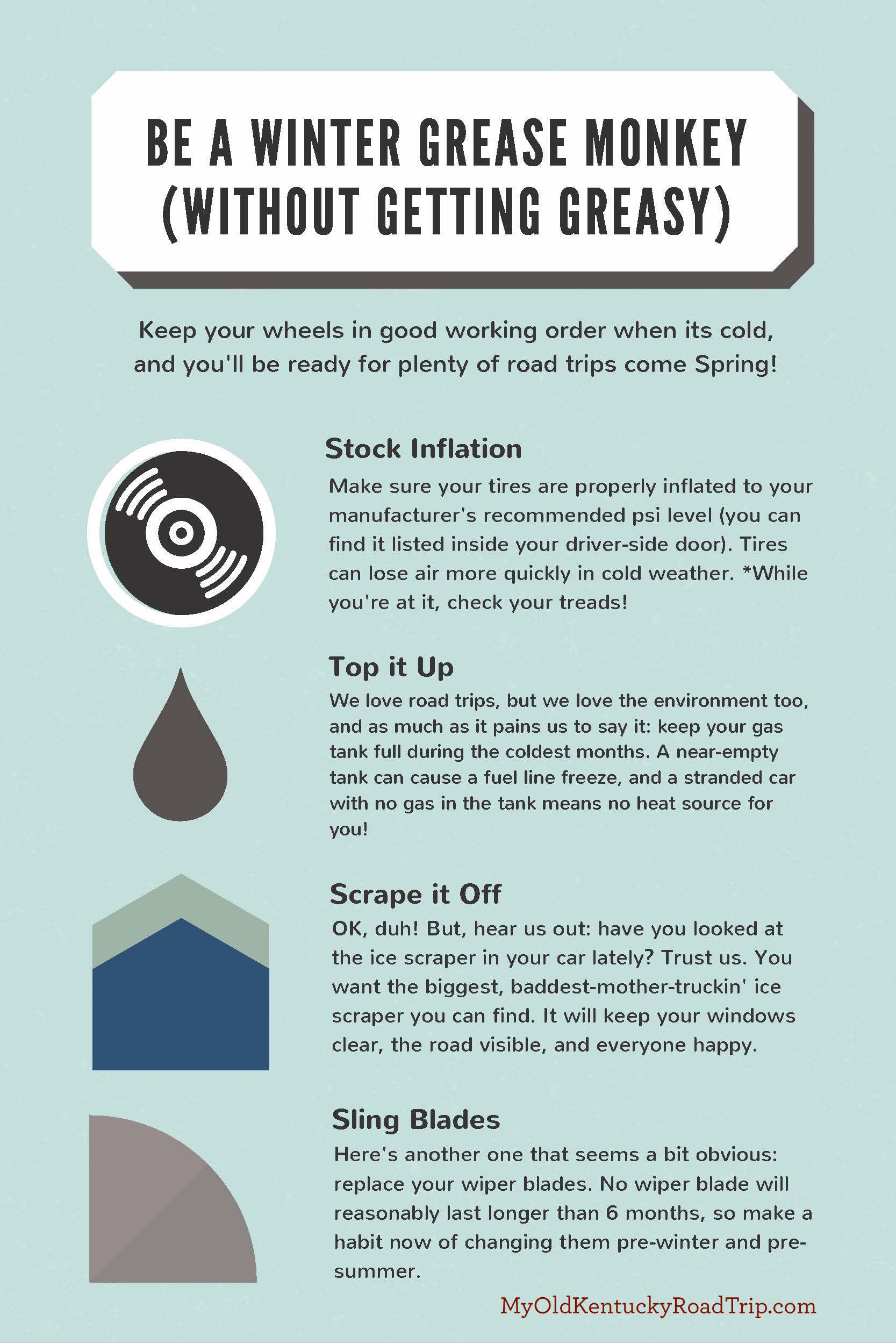
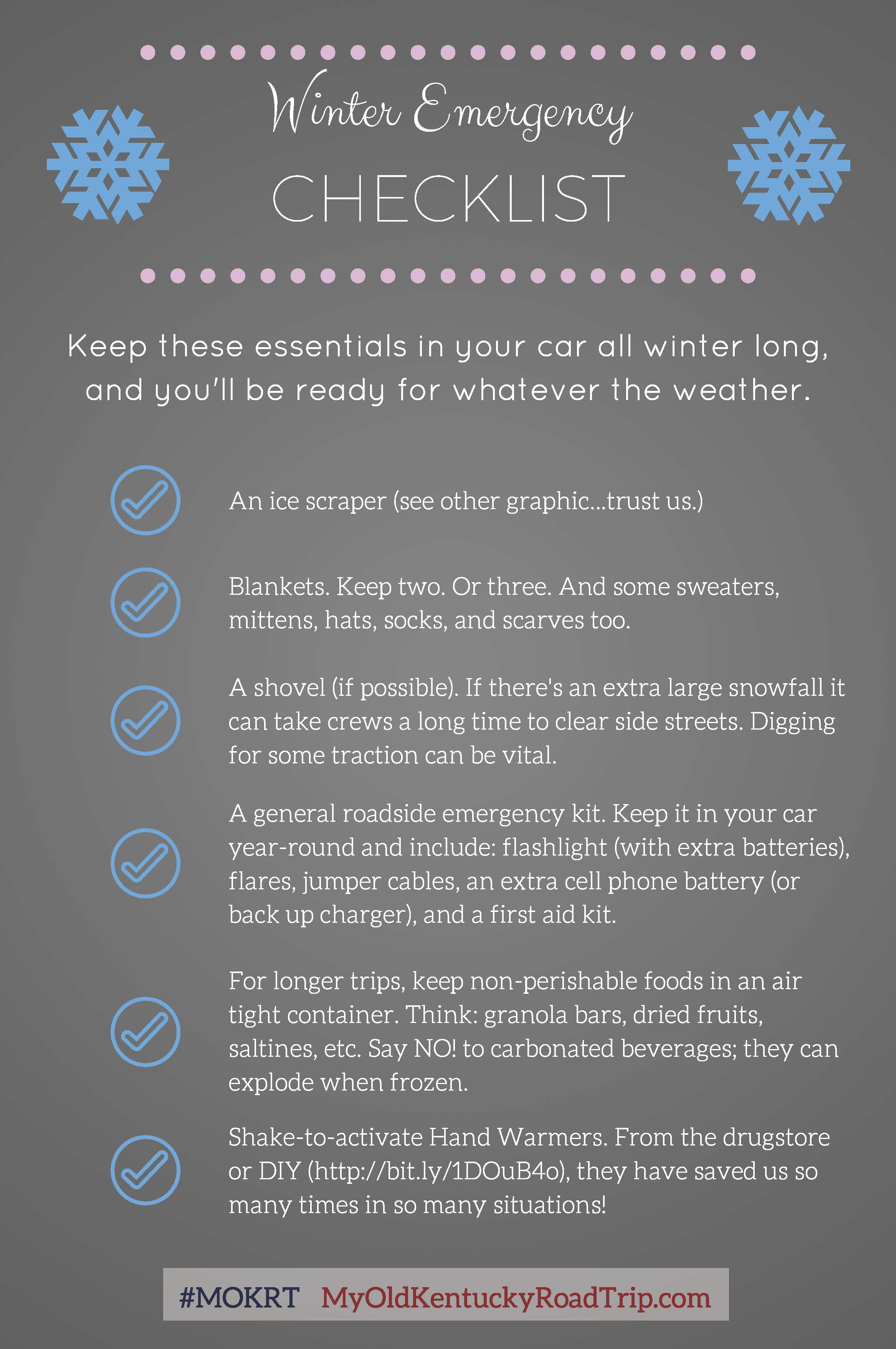
Its hard to be dedicated road trippers when the roads resemble an Olympic ice luge. Here’s the disclaimer: Please don’t drive on snowy, icy, or otherwise dangerous roads! We care about y’all way too much, and the world needs more safe road trippers, not less. Please, when in doubt, err on the side of caution.
That being said, if needs must—and sometimes, yes, needs must restock ice cream, pizza, and chardon…pardon, we meant, milk, bread, and eggs—you MUST make sure your faithful road trip car is in excellent working order and that you’ve got all the vehicular essentials in case of emergency.
As long time listeners of Car Talk (R.I.P. Tom!) and well-educated road trippers, we’ve created and kept up with our own Winter/Cold/Snowpocalypse Checklist to make sure our trusted wheels stay safe and happy, even if March comes in more like a polar bear than a lion.
For a full comprehensive list from the Car Talk guys, click here. AAA also has an excellent list of winter car essentials and cold weather driving tips here.
You might be so. over. the cold weather and already looking toward the beauty and fun that is springtime in the Bluegrass State (Kentucky Derby, anyone?) But! Let us tell you: don’t miss out on the fun to be had this winter.
Take advantage of the snow and go sledding! We’ve been told that Hospital Hill near Bowling Green is particularly awesome. We’re also partial to some of the hills in and around Cherokee Park, too.
And speaking of Cherokee Park, why not bundle up and go for a hike? The trails are easy to navigate, plenty of parking near trailheads, and you can count the icicles on Kentucky’s native flora. Further south, lace up your best snow boots and take a walk through Raven Run or Buckley Wildlife Sanctuaries. Meanwhile, in Eastern Kentucky, no one ever told us you can’t go hiking through the Daniel Boone National Forest in the wintertime…
Any outdoor warrior also knows that winter is the best time to see Elk. Buckhorn Lake State Resort Park posts times for Elk Watches each season, as does Jenny Wiley State Resort Park, but make sure you register first!
Other wildlife best seen in the colder months? Sandhill Cranes migrate through the Barren River Lake State Resort Park each year. Also in the feathered category are Bald Eagles. You’ll want to head West for the best Bald Eagle watching. You can take guided tours at four state parks: Kentucky Dam Village, Lake Barkley, Kenlake and Dale Hollow.
And just in case you get a little thirsty while you’re out exploring, Popular Science says it’s perfectly OK to eat snow! As long as its fresh and white…
We’ve been on some extraordinary road trips and more than a few amazing adventures across this great state together. Since we began this incredible journey more than three years ago—in April 2011, can you believe it?!—so many have joined us in our efforts to promote Kentucky travel to people around the state and others across the U.S. and the globe who haven’t had the chance to experience all of what the Commonwealth has to offer. For that, we are so, so grateful.
Now, we’re excited for you all to join us on our most unbelievable and exciting adventure yet.
Today, we’re officially announcing that we’ll have a book available in April! Featuring all of our favorite My Old Kentucky Road Trip stops, brand new road trips, and plenty of state history (and a few tall tales), My Old Kentucky Road Trip: Historic Destinations and Natural Wondersis available for pre-order on Amazon now. It’s a forreal book, y’all!
We’re so thankful for each and everyone of you who has visited our site, left us a comment, checked out our photos on Instagram, or shared your experiences with us on Facebook along the way. Connecting with fellow travelers who love roadtrippin’ as much as we do is the best part of this adventure for us. And the journey doesn’t stop now. We’re so very excited about the new book and the exciting opportunities it will afford us. But more than ever, we’re exciting to still be on the road, still be visiting the far corners and hidden gems that we haven’t explored yet. And we’re so excited to have so many Kentuckians, who are just as proud as their home state as we are, out there promoting Kentucky travel alongside us. Here’s to the Beautiful Bluegrass!
To kick off what we’re sure is going to be an exciting few months for us, we can’t wait to show you the cover of our book! Isn’t the photo of the Kentucky state capitol building in Frankfort beautiful?! Thanks to Elliott Hess Photography for My Old Kentucky Road Trip for capturing an amazing sunrise over the capital. This is one of the images featured on our book cover! What other iconic Kentucky images do you think we’ve included on the cover?
Stay tuned … we’ll reveal our book cover on Friday!
OK, not a car. But to us, this is just as exciting:
myoldkentuckyroadtrip.com is getting a new look!
We have some super exciting things happening in 2015! So to welcome the new year, we’re giving our site some shiny new wheels. Be patient with us as My Old Kentucky Road Trip undergoes some temporary construction, and get ready for some exciting NEW adventures very soon!
In the meantime ….
Are you out there roadtrippin’ across Kentucky? Post your photos on our Facebook page while you’re on the road so we can join in the fun! We’ll see you soon!
When we set out to explore the great state of Kentucky, we promised ourselves we’d explore every inch, every shadow, every hidden corner of our home. Ladies and gentlemen, let it be said that we’ve stood on the western-most tippity-tip of Kentucky looking out over the grand Mississippi River, and we came away with two thoughts:
1. Man, this is a big corn field.
2. How in the world did we get here?
Let me start at the beginning.
To get to the most western point of Kentucky located in Fulton County, you have to really want to go there. Like really, really bad.
The Kentucky Bend (also called the New Madrid Bend, Bessie Bend, or Bubbleland by locals for its odd teardrop shape) is an exclave of the state. This means that it is a piece of land belonging to Kentucky, but separated from the rest of the state entirely. Surrounded by Tennessee and Missouri and without touching any other part of Kentucky, the Bend is only accessible by Tennessee State Route 22. The 17 residents of this far-southwestern peninsula claim Tiptonville, Tennessee as their mailing address because the town 8 miles south is the closest post office. To vote, they make the 40-mile trip south into Tennessee then north back into Kentucky to Hickman.
You’re not just going to stumble upon these 15,000 acres. Well, I suppose you could if you get really lost. Or if you make a wrong turn leaving Tennessee’s Northwest Correctional Complex. Or if you’re an escaped inmate. But other than that, if you’re going to Bubbleland, you’re going there on purpose.
I couldn’t tell you how we got there, except to say we took the Purchase Parkway to US-51 to KY-94 (which leads you through the adorable sleepy town of Hickman that is home to one of the most friendly ferry drivers around … he’ll take you across the Mighty Mississippi to Missouri and back for a couple of dollars if you ask real nice) to TN-78 and then through a round about of detours to TN-22 heading north. You’ll pass a few grave yards, tens of thousands of acres of corn and soybeans and sweet sorghum crops, a state jail, and some friendly locals. And to get back, you’ll retrace your steps and do it all again.
A Little History Lesson
Now, it wasn’t always an (almost) island unto itself. In 1812, this area of the Mississippi River was disrupted quite a bit by a series of earthquakes along the New Madrid fault line that occurred in 1811 and 1812. If you ask the locals, the Kentucky Bend was created “when the Mississippi flowed backwards,” and rerouted, cutting off this bit of land from the area that would become the Jackson Purchase in 1818. The Bend was claimed by Tennessee for a while (and was part of Obion County), but around 1848, our southern counterpart dropped its claim on the 17.56 square miles of mostly cropland, and it became part of the Bluegrass State.
So here’s the real question road-trippers: Is one giant corn field and a couple of houses worth the trip?
It’s always worth the trip. Like us, many of you are from central, northern, eastern, or various other hollers and hills across Kentucky. And many of you have never taken the Bluegrass Parkway down to Western Kentucky Parkway over to the Pennyrile Parkway and connected to the Purchase Parkway. On your way to Fulton County in far western Kentucky, you’re going to pass through a ton of map dots that are worth slowing down for. Half of the fun of this road trip for us was the trip itself. It’s the journey, you know? It’s the gettin’ there that is full of laughter and singalongs and memories. It’s always worth the trip.
Plus, you, too, will be able to say you’ve stood on the most western tippity-tip of Kentucky.
So grab an overnight bag and make the haul down to Bubbleland. Stop in Hickman on your way and take the ferry across the Mississippi River to stand on the banks of Missouri and look at your great state across the water. Introduce yourself to locals. They’re proud Kentuckians, too.
Just don’t forget to pack your map. Cell phone and GPS services are rare and unreliable.
I’ve always wanted to see a moonbow. It was one of the things we put on our Road Trip Bucket List, and something I would recommend everyone see at some point in their travels through Kentucky.
It’s a phenomenon you can’t see anywhere else in the Western Hemisphere – the only other reported moonbow can be seen at Victoria Falls in Zambia in Africa. They’re rare because a lot of factors have to occur at the same time to produce the moonbow.
• There must be a bright, nearly full moon (usually 2 days before or 2 days after a full moon) and an almost cloudless night.
• Mist must be rising from the waterfall.
• Moonbows will appear white except on cold, crisp nights in the fall and winter when the atmosphere is drier and more clear. Then colors can be seen.
• Water temperature, fog and wind direction are also factors.
Lot’s of stuff to consider right? And there’s even more. Even if all of the above occurs, you still have to be in the right place at the right time to catch the moonbow. The time to view the moonbow depends on when the moon is high enough to shine over the mountain and into the river gorge. This can be as early as 7 p.m. in the winter and as late as 1 a.m. in the summer. It’s best to see the moonbow if you are standing along the upper outlook areas above the falls, looking down over the falls.
During Elliott and my recent trip to Cumberland Falls, we dedicated one of our nights to seeing this phenomenon. We were determined not to leave without it. It was the first weekend in March, still winter according to the crisp temperatures, and we lucked out because it was very clear and just a day after a full moon (OK maybe we didn’t luck out entirely, we sort of planned the dates of the trip around the elusive moonbow). Wrapped in layers and armed with a tripod, camera and lenses, Elliott and I arrived at the upper outlook at 8 p.m. and staked out the falls.
We didn’t see anything.
We waited some more.
Still nothing.
After about an hour of waiting, Elliott decided he didn’t think we were close enough. You see, usually at the park, you can walk out onto the rocks near the top of the falls and get closer to the water. But because of recent heavy rainfall, the barriers had been moved back, further from the water. So with a little minor trespassing, Elliott squeezed through an opening in the barrier and VERY CAREFULLY (I was freaking out internally the whole time) walked closer to the falls. Sure enough, peering over the edge of the rock, you could see the colorful arch in the mist rising from the water at the base of the falls.
So I joined him in his minor trespassing because I just had to see for myself.
Now, I’m not going to condone trespassing or breaking the rules. In fact, I’m going to pull a “do as I say and not as I do” parental moment and tell you to stick behind the barriers for your own safety. I have to tell you that. I don’t care for being sued.
But I’ll also admit this: I’m glad I followed Elliott out on that rock. It was one of the most fascinating things I’ve ever seen and by far a highlight to one of my favorite road trips.
Eagle Falls near Cumberland Falls State Resort Park in Corbin, Kentucky. Keep reading for the full story of our adventure, and visit http://www.elliotthess.com/blog for more lovely photos of the falls (including a moonbow picture!) Photo by Elliott Hess for My Old Kentucky Road Trip
When I was in elementary school, I loved to play The Oregon Trail computer game. Recently, some of Cameron and my friends downloaded The Oregon Trail game onto my iPad to relive one of our favorite childhood games. News flash: It looks totally different now. I mean, obviously this is to be expected. I hardly think Apple would let the old version of the game on their shiny hi-res screens. But still, a part of me was shocked to see the well-animated, bright and colorful game that played back at me. We were used to this version:
Nice outfits right? Perhaps it was because I had just been playing The Oregon Trail that my mind went straight to the game when the boyfriend, Elliott, and I took off on a road trip to Cumberland Falls State Resort Park a few weeks ago. Or maybe it’s because a lot of rain and some unplanned hiking trips made me wish I had a few oxen and a covered wagon. All in all, we had an awesome time at the falls and a couple of days of cloudy, but beautiful weather (Professional Photographer Elliott says cloudy days are the best picture-taking days … especially of water.) And we even got to see the world-famous Cumberland Falls moonbow – a phenomenon not found anywhere else in the Western Hemisphere. But we’ll tell you more about that later.
Let me back up a little bit. Here’s how the trip went:
Elliott had planned out a few hiking adventures on our drive to Cumberland Falls. He wanted to see nearby waterfalls like Eagle Falls and promised me they were “just off the road.” Perhaps we had a bit of a different definition of “just off the road.” To start our day off, the lady working the front desk at DuPont Lodge where we stayed – very nice and very affordable, a bit older since the lodge and its surrounding 15 cabins were constructed in 1933, but great views from the room – told us about a new waterfall that park rangers had just found days before (it’d been raining a lot recently) that was along a 1 mile hiking trail behind the lodge.
Well, we didn’t find the waterfall, but we DID get to climb across a massive fallen tree that completely blocked the hiking path and then navigate our way back toward the lodge on our own trail. Good thing I packed my hiking boots.
After making the (poor judgement) call to skip breakfast because we were desperate to see a waterfall at this point, Elliott and I drove the short distance from the lodge down to a small turn off and parking lot at the trail head to get to Eagle Falls. Here’s where The Oregon Trail comes into play. You see, just a short distance down the trail, we suddenly lost the path to the overflowing banks of the Cumberland River. Elliott decided we’d forge it.
So leaving our oxen and wagon behind (it was far too risky to take the animals along and Elliott didn’t want to get any scratches on his new covered wagon), and packing his camera, bag of camera gear and tripod (no room left for food), we crossed the river successfully.
But then we came across another river. Elliott wanted to forge this one, but I put my foot down.
The best part about the 2.5 mile hike to Eagle Falls (which involved many, many inclines both up and down and even more stairs), was we walked along the opposite side of the river from the state park viewing area. This meant we got a truly unique view of Cumberland Falls. That’s a lot of water.
OK, that part isn’t true. But I considered it for a half of a second. I blame hunger for clouding my judgement. If you want to orient yourself from the picture above, to Elliott’s right is Cumberland River, down river from the falls. Cumberland Falls is located over Elliott’s right shoulder, behind him about a mile.
Yes, it was a long hike. And yes, I was very hungry by the time we got back to our covered wagon and oxen Elliott’s car. But it was a lovely 2.5 mile walk to the falls and then the same distance back. It took us about an hour and a half to complete in it’s entirety (including some time we sat at the falls taking pictures), and on days in warmer weather when it hasn’t been raining a lot, I’m sure the hiking trails are clear and dry – no river forging necessary.
A little history about Cumberland Falls:
Because I couldn’t just leave you with our entertaining tale, a little history on Cumberland Falls –
Geologists estimate that the rock over which the Cumberland River plunges is about 250 million years old. Dr. Thomas Walker during his 1750 exploration of Kentucky named the waterfall after the Duke of Cumberland, a son of King George II of England.
Ownership of Cumberland Falls included Samuel Garland, a Virginian who traded a portion of his supplies for the land around the falls. He intended to build a water mill, but instead built a cabin in which he resided for a while before returning to Virginia. The first official record of the falls ownership occurred in 1800 when the Commonwealth of Kentucky granted Matthew Walton and Adam Shepard Cumberland Falls and 200 acres. In 1850, Louis and Mary H. Renfro bought 400 acres “including the Great Falls of the Cumberland.” The couple built a cabin near the falls and later added a two-room lean-to for visitors who wished to fish and enjoy the beauty of the magnificent waterfall.
After a few more owners, the Kiwanis Club sponsored the building of a trail from Corbin, Kentucky to Cumberland Falls in 1927. This project involved 200 men and women working for nine weeks to complete the task. In November 1927 Kentucky native T. Coleman DuPont offered to buy the falls and the surrounding acreage and give it to the commonwealth for a state park.
However, not until March 10, 1930 did the Kentucky legislature vote to accept the now deceased Coleman’s offer of the falls area as a state park. Coleman’s widow proceeded to buy the property of 593 acres for $400,000. Under the direction of Dr. Willard Rouse Jillson who had served as the first commissioner of state parks, a committee adopted a motion to make Cumberland Falls part of the state parks system. The dedication of Cumberland Falls as a Kentucky State Park took place August 21, 1931.
The road from Corbin to the falls needed improvement, and in 1931 a new highway was completed. Between September 7, and Thanksgiving Day, 1931, over 50,000 visitors came to see Cumberland Falls. Improvements to the park including the construction of DuPont Lodge have been made over the years and continue to be made today. You can find a complete history here.
What it’s going to cost you:
The park is free and open to the public every day until midnight. You can park and walk along a few paved trails that take you from the top of the falls to lower scenic overlooks at the base of the falls.
To stay at Dupont Lodge and it’s surrounding cabins, prices will vary from around $70 per night to a couple hundred per night for the cabins. For information about the park and to make reservations, visit the park website.
Directions:
It’s funny you’d ask because, well … we got a little lost. The gist of it is, you take Highway 27 in Kentucky to Highway 90 and follow signs to Cumberland Falls from there. We somehow missed Highway 90 and ended up taking Hwy 700 – which resembles a round on a Mario Kart track – which will intersect with 90 and get you back on track. My Garmin GPS did not have any luck finding the address to the park available on its website, but Elliott’s iPhone did find it.
A recommended detour:
After our hike to Eagle Falls, Elliott and I were ravenous. He talked me into stopping at a small restaurant on Highway 27 in Whitley City, about 15 miles back down Hwy 90 away from the falls and a few miles down Hwy 27. Milton’s Burger Hut had some of the most delicious food and friendly servers I’ve had in a while. Elliott took this visit very seriously. He ordered: meatloaf, mashed potatoes, green beans, a hamburger steak, fries, a buffalo chicken pizza, cauliflower nuggets and a 32 oz milkshake to top it all off. And our bill was still under $30. Seriously. I’d recommend it.
Cauliflower nuggets for your consideration – Milton’s Burger Hut, 740 N. Hwy. 27, Whitley City, KY
OK, don’t be fooled by the title of this post. I’m not going to bestow on you any deep knowledge about horses and safety. You want some REAL basic safety tips to keep in mind when you’re going to be around horses? Check out this list of tips from The Horsepedia. They’re serious and very helpful. (Like did you know you shouldn’t stand directly in front of a horse? They have a blind spot and can spook.)
This past weekend, I accompanied the Boyfried on a roadtrip to Cumberland Falls. I visited the lovely water falls, Eagle Falls and even got to see a moon bow! And I only participated in a minor amount of trespassing, which is a major accomplishment. While I’m putting together my thoughts from my most recent trip, and waiting on the Boyfriend to tone his beautiful moon bow pictures, here is a little in between post to hold you over.
Going through some pictures a few days ago, I came across these photos that were taken over the Christmas holiday at a close family friend’s horse farm in Lexington. After our annual Christmas Even brunch, my brother announced to the room that he couldn’t remember the last time he’d touched a horse. Which apparently, given he was from Lexington, was startling to him and half the room’s occupants. So we marched him outside – a few carrots in hand – to a field with a few horses enjoying the unseasonably warm weather. The following occured:
Brian begins feeding horses.
Horses are thankful for the delicious afternoon snack and want to thank Brian for his kindness. Brian is overly pleased with himself.
Horses are still hungry. Brian tries to turn them down, informing them they’ve had enough. Horses do not take well to Brian’s superior attitude. Horses turn Brian into snack.
Horses swallow him whole. Christmas is ruined.
OK, well the last part isn’t true. But here’s your horse safety tip for the day: When feeding a horse, let him tell you when he’s finished. And definitely don’t give him the impression that you are calling the shots. He’s bigger than you are (ahem, Brian).
So glad you’re educated now.
Top photo by Elliott Hess for My Old Kentucky Road Trip, www.elliotthess.com.
 Tandy Ellis’ Burgoo Recipe